Chases of 2013
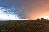 |
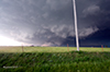
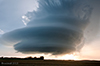
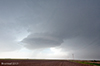
June 11 | I chased a non-tornadic supercell in the Nebraska panhandle. Storms did not develop until near 730 MDT as forcing finally reached the high Plains. Initially convection was generally associated with an ACCAS field, but eventually become rooted in the boundary layer. This supercell was tornado warned as produced a well developed wall cloud and a nicely structure barrel shaped updraft. |
 |
May 31 | Details coming soon... |
| May 30 | ||
| May 29 | ||
| May 28 | ||
| May 27 | ||
 |
May 26 | Details coming soon... |
| May 25 | ||
 |
May 24 | Details coming soon... |
| May 18 | ||
| May 8 |